
Walks Program

Jul 23 (Thu) BRISBANE WATERS - WOY WOY CIRCUIT - Cycling
Catch the train to Woy Woy & ride anti clockwise around Brisbane Waters mostly on shared pathways & on road cycle routes. Woy Woy, Ettalong, Umina, Rip Bridge, Empire Bay, Bensville, Kincumber, Davistown, Satatoga, Green Pt, Erina, Gosford, Pt Clare, Tascott, Koolewong, Woy Woy.Please ring to confirm details etc by Tues. Helmets, Hi Vis jackets, sunscreen, water, spare tube, pump & repair kit required. Limit 8. DISTANCE: MEDIUM. TRIP GRADE: MEDIUM MAPS: STREET DIRECTORY. TRANSPORT: Bike
Jul 25, 26 BLUE MOUNTAINS NP (Q)
Victoria Falls Road, Asgard Swamp, base camping at Asgard Swamp, then doing day walks to Asgard Head & Thor Head. Great views of the Upper Grose Valley. Prospective members welcome. DISTANCE: MEDIUM. TRIP GRADE: EASY/MEDIUM MAPS: MT WILSON 1:2500. TRANSPORT: $44. Can pickup from Mt Vic station.
Jul 28 (Tue) KAMAY BOTANY BAY NP
La Perouse, Congwong Bay, follow the track through bushland to Cruwee Cove, Cape Banks and return the same way. Great coastal scenery, historic interest, maybe spot a whale. DISTANCE: SHORT. TRIP GRADE: EASY MAPS: WALKING COASTAL SYDNEY, CLOVELLY TO CRONULLA. TRANSPORT: BUS
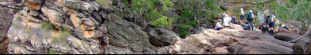
Aug 11 (Tue) BRISBANE WATERS NP (Q)
Mt Pindar Lookout and Cave. Classic walk from Wondabyne Station. Enjoy the early spring flowers and terrific views over the Hawkesbury River. DISTANCE: MEDIUM. TRIP GRADE: MEDIUM MAPS: GUNDERMAN. TRANSPORT: TRAIN
Aug 13-21 OVERLAND TRACK, TASMANIA (QQ*)
North to South, start Cradle Mtn, 8 nights, 9 walking days, finish Lake St Clair visitors centre. On tracks/boardwalks, staying in or near huts but winter grade tents required. Opportunities for day trips to near-by peaks, weather permitting. Stunning scenery, weather permitting. EOIs sought. I have booked for 6 persons, want a minimum of four for this to proceed. Planning trip to start and finish in Hobart, with chartered bus transport in between. Minimal park permit fee will also apply. Itinerary flexible at this time, weather dependant, including boat trip down Lake St Clair at end (instead of walking the sublime track, approximately 16 kms). Stoves only. DISTANCE: MEDIUM. TRIP GRADE: MEDIUM MAPS: SEE LEADER. TRANSPORT: $LOTS . * The Walks Secretary has designated this trip as worth TWO Q walks towards qualifying for full membership of CMW. ** LEADER ADVISES: The Trip is now FULL. **
Aug29-Sep9 LITCHFIELD NP AND NITMILUK NP (NT) (QQ*) (Q)
Tabletop and Jatbula Tracks. The Tabletop Track loops around the Tabletop Range in Litchfield National Park and is planned as a 4-day hike through savanna woodlands, monsoon forests, scenic pools and rugged rocky landscapes. The Jatbula Track is located in the stunning Nitmiluk National Park and will be completed over 6 days. Jatbula Track permits are extremely difficult to secure, and I have managed to obtain 5 permits. Party limit of 5. Walk grade is closer to the CMW medium grade, however it will be hot and NT Parks grade both tracks as Grade 4 (moderate to difficult). Both walks are exploratory for the leader. There is 1 spot remaining, if you would like to come please contact me ASAP. DISTANCE: MEDIUM. TRIP GRADE: MEDIUM/HARD MAPS: LITCHFIELD NATIONAL PARK, NITMILUK NATIONAL PARK - JATBULA TRAIL TRANSPORT: LOTS
Sep 5, 6 GARDENS OF STONE NP (QQ*)
Baal Bone Gap, Pantoneys Crown, Crown Creek, Point Cameron, McLeans Pass, Baal Bone Gap. Fabulous camping on top of the Crown. Must carry water for the night which we should be able to replenish at Crown Creek. Amazing pagoda country. Some climbing and descending involving use of a tape. It has been a long time since any of us have visited Pantoneys but I thought now is a good time with the road being in much better shape than it has been for a very long time. DISTANCE: MEDIUM. TRIP GRADE: HARD MAPS: BEN BULLEN. TRANSPORT: $72. * The Walks Secretary has designated this trip as worth TWO Q walks towards qualifying for full membership of CMW.
Nov 1-6* SOUTH COAST NSW (Q)
Camp for 5 nights (Sunday to Friday) or come when you like. Join me to do some great day walks in this beautiful area of the Sapphire Coast, with plenty of swimming, walking and relaxing if good weather. We’ll look at climbing Mt Pigeon House. A mix of long and short walks to suit the party. Staying at Lakesea Caravan Park,South Durras. There are a number of options with Cabins:3 bedrooms, 2 bedrooms,1 bedroom; caravan sites with ensuite and camping. DISTANCE: MEDIUM. TRIP GRADE: MEDIUM. MAPS: KIOLOA, DURRAS. TRANSPORT: $116
Nov26-Dec1 CROAJINGOLONG NP
A return to this area where our club members have enjoyed spending time camping, walking, talking and just lazing around. Base Camp next to the lagoon and beach at Thurra River, day walks only. Our booking is secured, please contact me to book your place. Party limit. DISTANCE: SHORT. TRIP GRADE: EASY/MEDIUM MAPS: NAT MAP CANN 1: 100, 000. TRANSPORT: $195